


Trip description
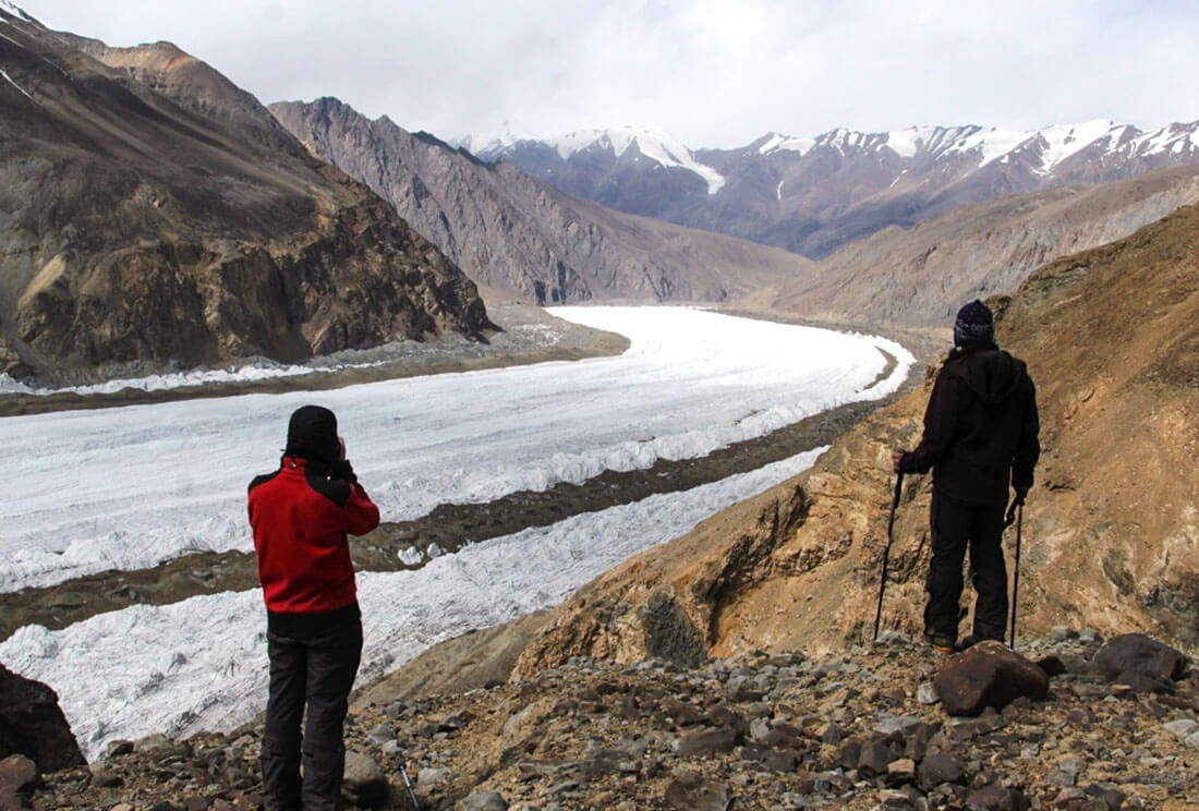
This tour specially designed for a real adventure, with a demanding trekking without fixed paths (as the glacier changes a lot every year) or any accommodation, you will probably reach your physical limits. As a reward, you will take the unique opportunity to see the phenomenal kingdom of ice - Fedchenko Glacier, located in the heart of Pamir Mountains of Tajikistan. With a length of 75 km and a width of 2-3 km, Fedchenko is the longest mainland glacier in the world, outside of the polar glaciers and Greenland. Countless peaks of the region are still unnamed and unclimbed, since the entire region only occasionally visited by small expeditions. In many places, the access is only possible on foot and therefore quite cumbersome. In general, very few tourists still get lost in this fabulously beautiful region.
A very demanding terrain, with steep abseiling, rivers to cross, scree, crevasses and passes at almost 5000 meters above sea level. The use of mountaineering gear (see the recommended equipment list ) and previous glacier experience is highly recommended.
A good fitness is simply necessary to participate in this tour, even if porters carry most of the luggage and camping gear, each participant must carry part of the food, and personal belongings. It is possible to hire extra porters, but should be condemned in advance. After stepping into the glacial surface, the group will be self-sufficient for 14 days. In this trip, you will follow the trail of a German-Soviet expedition of 1928
An experienced mountain guide and his assistants will accompany the group to provide the security and coordinate the movement of the group. The group size is limited: from 3 to 6 people.
Fedchenko Glacier
Fedchenko Glacier – the world largest glacier outside of polar glaciers. Situated in Central Pamirs, Fedchenko glacier is 77 km long and from 2 to 3 km wide and covers about 992 square km of the area. The glacier flows to north from the great ice field of Revolution peak 6974m and forms the headstreams of Amudarya, Surkhob, Vakhsh and Muksu rivers. The thickness of the ice in the middle of the glacier is approximately 1000 meters and the rate of movement is about 66.8 centimeters in 24 hours. The highest altitude of the glacier is 6280m and the lowest point is 2900m, the snow line starts from 4650m.
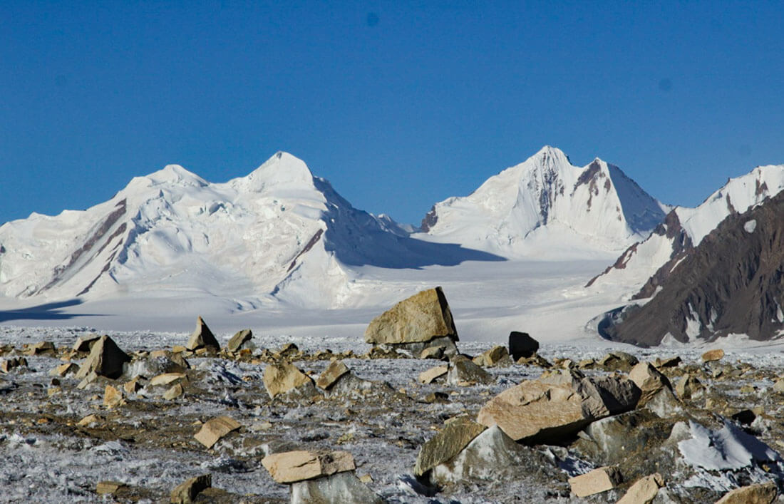
Fedchenko Glacier was discovered in 1878 but not fully explored only untill 1928 by Soviet-Germany expedition headed by Willi Rickmer Rickmers. It was named after Soviet scientist and explorer Alexei Pavlovich Fedchenko, but he did not discover it first. Traveling on the glacier you can see the highest peak of Tajikistan – Ismoil Somoni (ex- Communism) peak 7495m, almost from all points.
Note:
The challenging terrain of the route does not allow the use of pack animals for transportation, all group equipment and food will be carried by porters. All participants on this tour are recommended to stock up on Meals Ready to Eat or MRE for short - freeze-dried travel food that only requires heating or adding boiled water, for 14 hiking days.
Itinerary
Arrival in Dushanbe airport transfer to hotel. The day begins with cultural immense: Vizit of National Antiquities Museum (archaeological museum), which houses numerous artefacts from the Sogdian, Greco-Bactrian and Kushan periods. One of the famous artefacts of this museum is Buddha in Nirvana, a lying 14m statue of Buddha, known as the largest surviving Buddha statue in Central Asia and the longest terracotta Buddha in the world, after the destruction of the Buddha statues in Bamian of Afghanistan. You will also find the legendary Bronze Age Princess of Sarazm, discovered from the famous 5500 years old Sarazm city, listed in UNESCO world Heritage sites. Lunch in traditional restaurant. After lunch, the group can make a free exploration of the city, while the support team will finalize last preparation for the trek.
Sightseeing: about 4 hours
Final altitude: approximately 800 m
Meals: breakfast in hotel – lunch and dinner in restaurants
Accommodation: Hotel
Today we have long drive, so we have to start earlier. After breakfast, the journey begins on the legendary Pamir Highway. Deep gorges, wide plateaus, spectacular mountains - a grandiose road over the "roof of the world". The journey goes through beautiful landscapes with remote villages. An original region, almost untouched by tourism. You tackle the first section of the Pamir Highway with the Shurabad Pass (approx. 2,300 m) After 10 hours we reach Rushan – a small district full of green villages. Dinner and overnight in guesthouse.
Driving time: about 7 hours
Elevation: + 1000 m / - 200 m
Final altitude: approximately 1,800 m
Meals: breakfast in hotel – lunch in café – dinner in guesthouse
Accommodation: guesthouse
To reach the last point possible to drive by car, we need to cross the Bartang valley, very famous in High Pamirs with dangerous roads, floods and ragging Bartang River. Our journey takes us through small and green villages like the real oases in the middle of plains of stones. In winter, they are completely cut off from the world. At 3000 meters altitude, the slopes of the mountain are draped in a blanket of snow and the roads blocked. After around 6 hours shaky drive we reach Pasor – the last village, from where the expedition begins. We finalize the last preparation and stay overnight in homestay.
Driving time: about 6 hours
Elevation: + 1130 m / - 200 m
Final altitude: approximately 3,030 m
Meals: breakfast in guesthouse – picnic lunch – dinner in homestay
Accommodation: homestay.
We leave Pasor village by a small path that runs along a torrent and goes into the mountains. The idea is to start the ascent very gradually. First to acclimatize to the altitude, but also because it is at the start of the expedition and the group is the most loaded. Porters to carry the food and the camping gear will accompany the group, but for the first days, we use the pack animals to relieve the porters. We pass a small hydroelectric plant, running at full speed and provides electricity all year round to the 200 inhabitants of the village. The cultivation of wheat, vegetables in greenhouses and the breeding of cows and goats allow the locals to survive in these isolated lands. After 5 hours hiking and 450 m gained altitude, we set up a camp near the torrent. Overnight in tents
Hiking time: about 5 hours
Elevation: + 450 m / - 70 m
Final altitude: approximately 3,435 m
Meals: breakfast in bivouac – picnic lunch – dinner in bivouac
Accommodation: overnight in tents
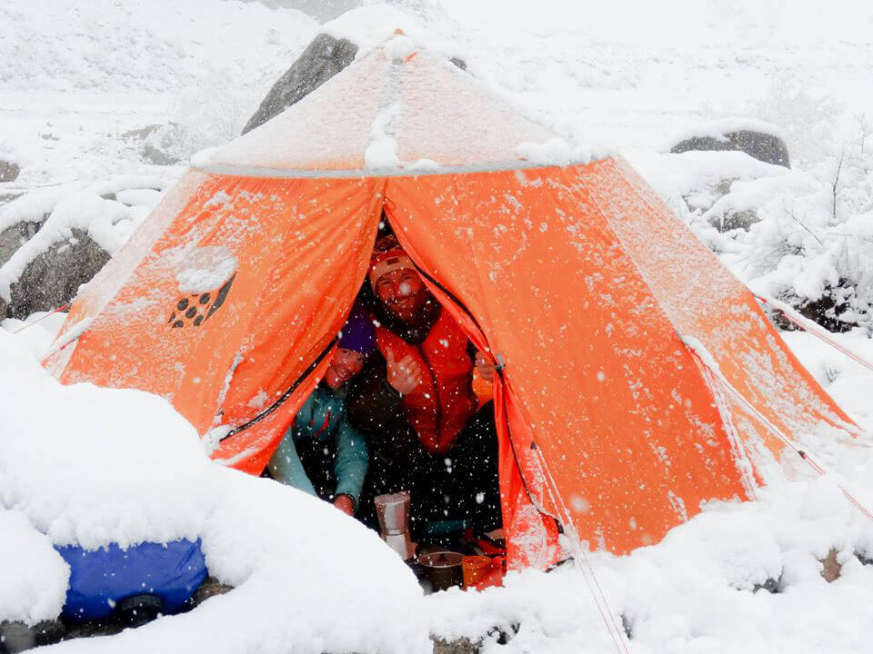
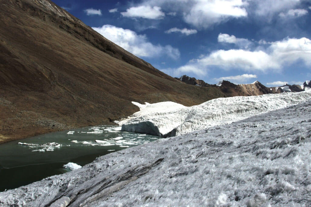
It will take around 8 hours of hiking before we reach Khafraz Lake located in 4000m. The lake is housed in a crater, surrounded by sharp peaks; its emerald green color is surreal. The climate is specific for this region, during the day, the sun is so strong that you have to wear long sleeves and cover your face (except to pose for a photo). At nightfall, the temperature is around 5°C and the temperature drops very suddenly as soon as the sun disappears. Here the presence of a human is so imperceptible, it seems that these landscapes will not change for centuries. Overnight in tents
Hiking time: about 8 hours
Elevation: + 585 m / - 85 m
Final altitude: approximately 4,020 m
Meals: breakfast in bivouac – picnic lunch – dinner in bivouac
Accommodation: overnight in tents
Today the pack animals finalize their mission. In lunchtime, we reach Kholodnaya Stena (Cold Wall) glacier, from this point all the food and camping gear will be transported by porters. We climb the pass Kholodniy (Cold) 4665m and reach the Glacier Lake. Overnight in tents
Hiking time: about 8 hours
Elevation: + 650 m / - 0 m
Final altitude: approximately 4,520 m
Meals: breakfast in bivouac – picnic lunch – dinner in bivouac
Accommodation: overnight in tents
We start the day with a 60-meter abseil on a steep, icy slope. The descent is enough dangerous with risk of rock falls, so the group will descent one by one with top belay. The guide and his assistant will control the process. The glacier tongue is huge and flows between two ocher-colored mountainsides. We descend to an altitude of 4200 meters and set up camp earlier in order not to be surprised by the night, which fell very quickly and usually be accompanied by temperatures below 0°C. It's not easy to find flat ground to pitch the tent, so we need to terrace a bit, removing the biggest stones and cutting the ice with our ice axes. Overnight in tents
Hiking time: about 6 - 8 hours
Elevation: + 0 m / - 470 m
Final altitude: approximately 4,200 m
Meals: breakfast in bivouac – picnic lunch – dinner in bivouac
Accommodation: overnight in tents
Today we continue the descent down to the valley. The terrain is soft and the risk of rock fall requires using the rope for belaying. We will descend carefully, one by one, holding the rope firmly in our hands. The ground is soft so our passage can loosen the big stones; we need to be very careful. After this technical passage, we set foot on the Grum Grzhimailo glacier. If you find it great, wait, until you see the Fedchenko! We must reach the left bank of the glacier to reach the green Tanimas valley, which will lead us to Fedchenko glacier. However, it is a real chaos of ice, crevices and rivers of melt water. It is a real labyrinth! After walking by the scree, descending to 4000m, we rfound some vegetation and we walk with a little more ease on this flatter ground. Overnight in tents
Hiking time: about 7 hours
Elevation: + 0 m / - 480 m
Final altitude: approximately 3,720 m
Meals: breakfast in homestay – picnic lunch – dinner in bivouac
Accommodation: overnight in tents
Reserve days are necessary to prepare the group before technically difficult sections of the route, rest and in case of bad weather.
Final altitude: approximately 3,720 m
Meals: breakfast in homestay – picnic lunch – dinner in bivouac
Accommodation: overnight in tents
Tanimas valley borders with several glaciers, which feed a river with a very powerful flow. We carefully follow the guide’s recommendation and start one by one to cross the river belayed on rope from two sides of the harnesses. The flow of the river is quite fast and it comes up to our waists. We have to cross this river again later, but if the level of water is too high, we will do it in the morning when the glaciers are still frozen and less exposed to the sun. Overnight in tents.
Hiking time: about 6 hours
Elevation: + 50 m / - 0 m
Final altitude: approximately 3,750 m
Meals: breakfast in bivouac – picnic lunch – dinner in bivouac
Accommodation: overnight in tents
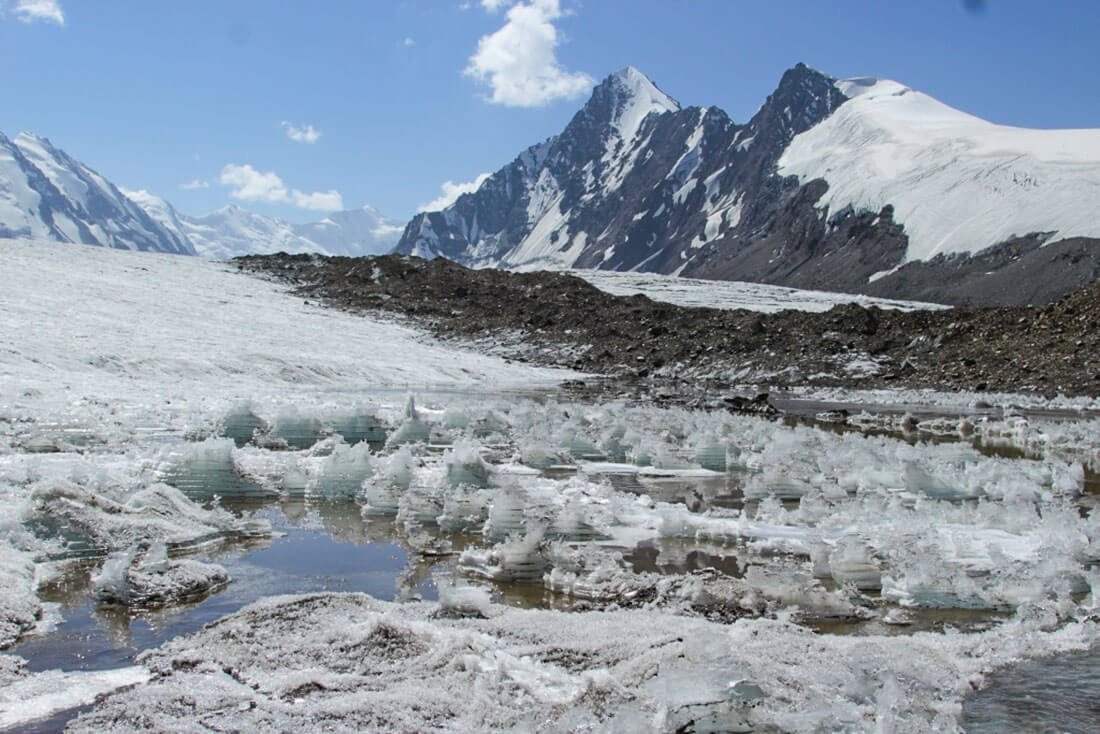
Today we have a river-crossing day! We start very early when the level of water is lower. We have to cross with a harness around the waist, barefoot and in underpants. The water can rise up to our thighs, and it is biting cold. There will be several river crossings today. This is the main reason, why we run this trip in September, when the water level is at its lowest line, as summer has passed and all the spring snow has melted. We spend a good part of the afternoon crossing a new glacier, the Tanimas 3 glacier. It blocks the whole valley. We cross it carefully we go through it, stepping over the thin crevices that fracture it and finally reach the top of the valley at 4500 meters above sea level, which opens onto a glacial lake with a small part of the Fedchenko glacier. Overnight in tents.
Hiking time: about 8 hours
Elevation: + 200 m / - 30 m
Final altitude: approximately 4,500 m
Meals: breakfast in bivouac – picnic lunch – dinner in bivouac
Accommodation: overnight in tents
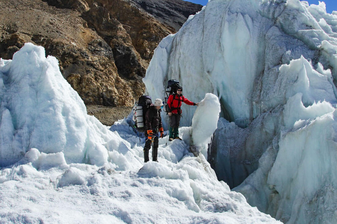
Finally, we will set a foot on the Fedchenko glacier! It is a monster of ice - 77 kilometers long, which makes it the longest mountain glacier in the world! It is surrounded by mountains culminating at more than 7000 meters of altitude and its thickness reaches up to 1500 meters. The Fedchenko Glacier, and all the glaciers of the Pamirs, serves as a fresh water reservoir of Central Asia. We descend the glacier surface all day. If it is sometimes quite flat and allows us to move quickly, but often we have regularly slowed down by crevasses and the rivers of melt water. Overnight in tents
Hiking time: about 8 hours
Elevation: + 580 m / - 545 m
Final altitude: approximately 4,520 m
Meals: breakfast in bivouac – picnic lunch – dinner in bivouac
Accommodation: overnight in tents
Gorbunov Meteo Station was built in 1933 by Soviet Union in 4230m elevation. It was active until 1991, about four people stay to work there for a year (from November to November) to take meteorological readings: measuring the temperature, precipitation, wind speed etc. The station abandoned in 1991 with the fall of the USSR. Inside the metallic building, it seems the time stops in 1991; everything stays as if the people left yesterday. There is a whole bunch of measuring devices, a radio, a room with generators, a library, coal stoves, the wals covered with posters of Madonna.. Now, the modern automatic weather station installed and the data it returns are crucial for observing the state of the Pamir glaciers. These glaciers serve as a freshwater reserve of Central Asia, which gives life to this region of the world. Surprisingly these glaciers do not retreat and seem preserved from global warming. This is the Pamirian exception and this is good news. They are the guarantors of stability, prosperity and peace in the region.
We take possession of the premises and can eat our meals seated around a table, which is a small event after 10 days sitting on the floor. Tonight we sleep there. Overnight in tents
Hiking time: about 7 hours
Elevation: + 70 m / - 450 m
Final altitude: approximately 4,230 m
Meals: breakfast in bivouac – picnic lunch – dinner in bivouac
Accommodation: overnight in tents
Reserve days are necessary to prepare the group before technically difficult sections of the route, rest and in case of bad weather.
Final altitude: approximately 4,230 m
Meals: breakfast in homestay – picnic lunch – dinner in bivouac
Accommodation: overnight in tents
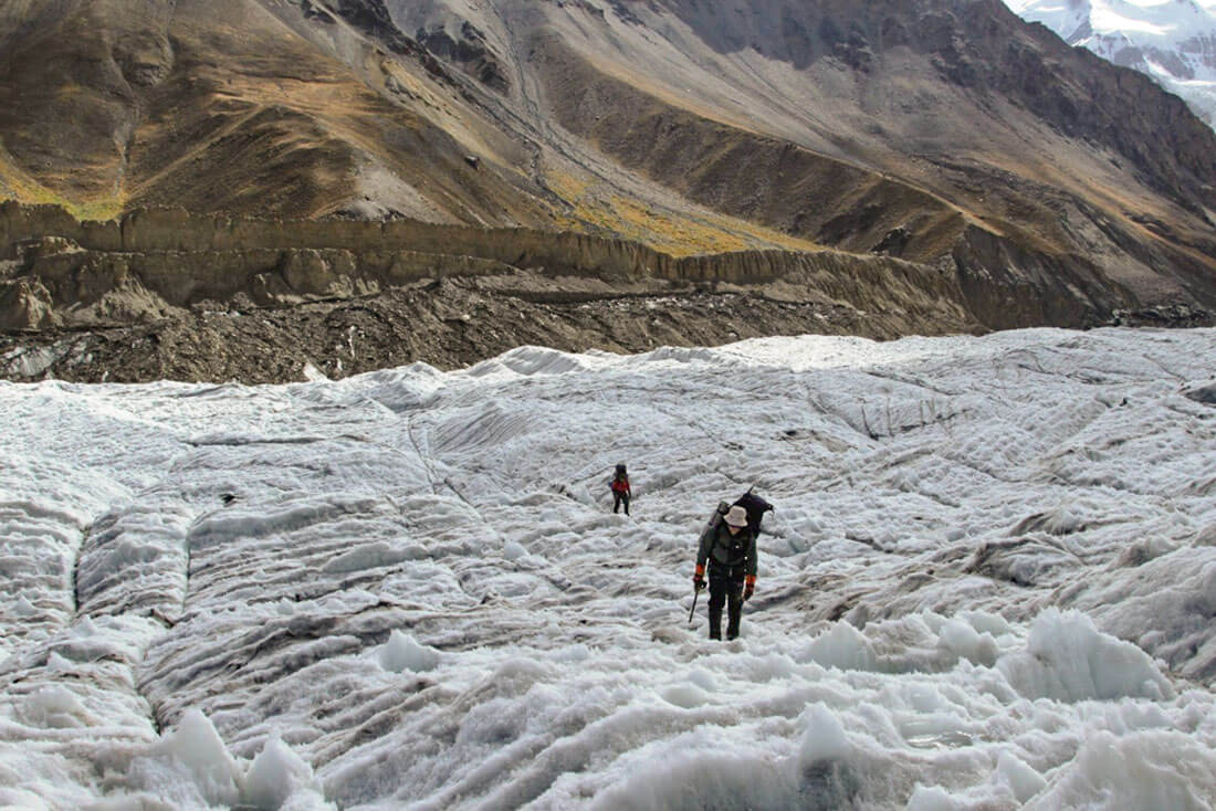
We start from the Gorbunov station at sunrise. Arriving at the glacier, we divide the group into two team. At the end of summer, the glacier is open from the snow and we can see the numerous snow bridges and crevasses, we have to pass, but we have to be careful. With an ice ax in one hand and a cane in the other, we climb the glacier slowly, gradually. We step over tight rope gaps without stopping. We ascend Kashalayakh pass higher than the classic route in 4500m and have a great view from top. Than we start the descent to beginning of rock belt to 4200. Overnight in tents
Hiking time: about 6 hours
Elevation: + 300 m / - 300 m
Final altitude: approximately 4,200 m
Meals: breakfast in bivouac – picnic lunch – dinner in bivouac
Accommodation: overnight in tents
Today we have to descend a whole section of the mountain and reach a new glacier in the valley called RGS (Russian Geographic Society). The descent into the stones is slow and technically hard. We make a reminder on a technical passage. Once arrived below 4000 meters, the landscape changes, vegetation and flowers accompany our descent. Be careful with the rock-falls and slip terrain. After a long descent, we put our tents closer to the water for dinner and stay overnight here.
Hiking time: about 7 hours
Elevation: + 0 m / - 1,400 m
Final altitude: approximately 2,800 m
Meals: breakfast in bivouac – picnic lunch – dinner in bivouac
Accommodation: overnight in tents
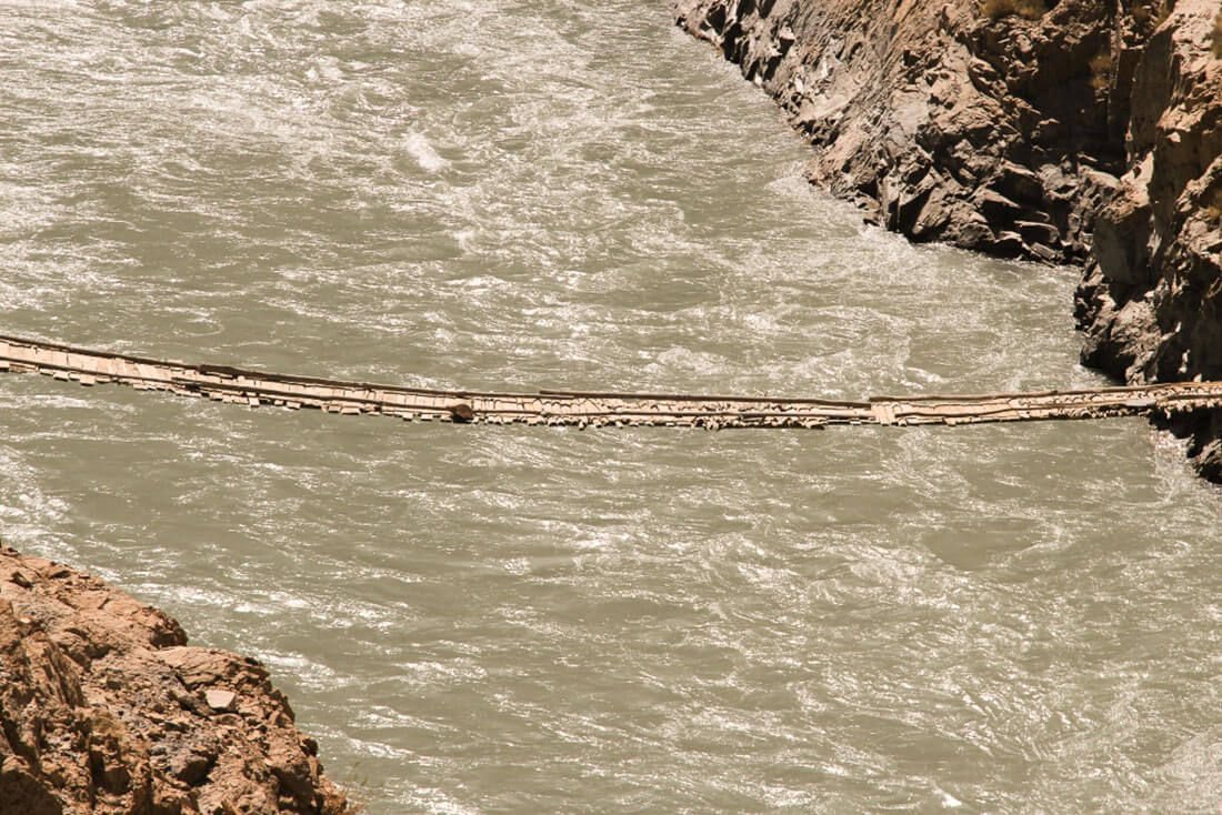
Today we continue over the glacier called RGS, while flowing towards the valley, moved a phenomenal quantity of sediments and created hills of stones, earth and dust that we have to pass. The terrain gets very unstable in some places; the stones can roll under the feet and throw you off balance, so we move carefully. At lunchtime we arrived at the river, we are not at the end of our effort. The bridge that connects us to Poimazor collapsed a few years ago following a landslide. Fragments of concrete, steel and cables remained. The river is far too high and the current too powerful to hope to cross on foot. It is on a cable that we will reach the other side. Bag by bag, one by one, we engage in crossing belayed to the cable after a pair of hours, we are all on the other side, where our driver is waiting for us with a big Soviet truck. The truck is the only possible transport, enough powerful to afford the rivers and dirt road to Poymazor. But this is also a part of an adventure! Tonight we finally have access to home meal, beds and shower after long trek on glaciers. Overnight in homestay in Poymazor.
Hiking time: about 3 hours
Cable cross over the river – 2 hours
Elevation: + 0 m / - 200 m
Final altitude: approximately 2,600 m
Meals: breakfast in bivouac – picnic lunch – dinner in homestay
Accommodation: overnight in homestay
After breakfast we meet our drivers , load the luggage and continue our journey to Dushanbe. If the road is open this time, we take southern road via Khaburrabot pass. After arrive in Dushanbe, transfer to hotel. Farewell dinner with the guide and drivers. Overnight in hotel.
Driving time: about 8 hours
Elevation: + 200 m / - 1400 m
Final altitude: approximately 800 m
Meals: breakfast in hotel – lunch in cafe – dinner in restaurant
Accommodation: hotel
Doing the PCR test and other formalities before leave. Overnight in hotel in Dushanbe. Our service will ends with transfer to airport. Hope you enjoyed your trip!
Flight back home!
Dates & Prices
| Dates | Availability | Prices | Single suplement |
|---|---|---|---|
| 3 Sep – 27 Sep | Available | US $3,600 | US $400 |
What’s included
- 7 breakfasts, 6 lunches, 6 dinners (snacks & picnic lunches on trek)
- Private Transportation: 4WD vehicles with drivers
- Truck for drop off to Poymazor
- Bottled water provided during the tour, boiled water during trek)
- Airport transfers on arrival and departure days
- Accommodation in 3* Hotel single/twin share rooms in Dushanbe
- Guesthouse and Homestay accommodations en route
- Twin share tents on trek
- Service of professional mountain guide
- Mountain guide assistant
- Tajik National Park entrance fees and trekking permits
- Pack animal support to reach the glacial part of the trek
- All group camping equipment
- All group climbing gear
- All group cooking gear
- Gas for cooking
What’s not included
- Personal equipment (see the list below)
- Visa and GBAO permission
- International flights
- Hot meals during the trekking part
- Tips, alcohol, personal expenses
List of Equipment recommended for this trip
Basic Equipment:
- Iso-mat (suitable for snow / ice subsoil)
- Accessory cord 12 m
- 5x carbine hoeses
- adjustable mountaineering harness
- ascender
- icecrew
- ice axe
- Thermo underwear (2 sets, 1 x long-sleeved , 1 x shortsleeved)
- 1 pair of gaiters
- warm cap
- warm gloves (e.g., ski gloves or woollen mittens)
- 1 sleeping-bag (down or hollow fiber) suitable to - 15 ° C
- 1 forehead lamp or flashlight
- Solar protection (headgear, sunglasses, solar cream)
- personal medication (pain means, fever-lowering drugs, diarrhoea medications, means for wound disinfection, plaster, bandages, elastic bandage, small scissors, tweezers, safety pins, medicine against flu, sore throat and coughing, eye drops)
- 2 long trousers, one of it trekking trousers
- 1 pullover (woollen or fiber fur)
- Sea bag or backpack for the main luggage
- ankle-high trekking shoes with profile sole and matching climbing irons
- Telescope ski sticks as a walking help
- Water bottle with 1 litre of capacity
- Thermos bottle with 1 litre of capacity
- suitable hiking clothes (T-shirt, hiking socks)
- 1 anorak, wind and water proof (e.g., Goretex)
- 1 overtrousers, wind and water proof (e.g., Goretex)
- Toilet paper
- personal dishes spoon, fork, small knife, soup plate, mug (unbreakable and light material)
Additional Recommended Equipment:
- Rain protective covering for the backpack
- Comfortable shoes or sandals
- Photo equipment, films, binoculars
- Penknife